
Land Subsidence: Causes, Monitoring Techniques, Impacts, and Mitigation Strategies
Introduction
Land subsidence is a slow but often irreversible geohazard resulting from the gradual sinking of the Earth’s surface. In many regions, subsidence is closely linked to excessive groundwater extraction, mining activities, underground construction, and natural geological processes. With increasing urbanization and water demand, land subsidence has emerged as a critical risk to infrastructure, flood safety, groundwater sustainability, and climate resilience.
In India and globally, several cities and industrial belts are already experiencing measurable subsidence, amplifying flood risk, damaging buildings and utilities, and altering natural drainage systems. Understanding the causes, monitoring methods, and mitigation strategies is essential for sustainable land and water management.
What Is Land Subsidence?
Land subsidence refers to the downward movement of the ground surface caused by changes in subsurface conditions. It is typically gradual and difficult to detect visually until significant damage occurs.
Subsidence may occur over localized areas or across entire regions, depending on the extent of subsurface stress and groundwater withdrawal.
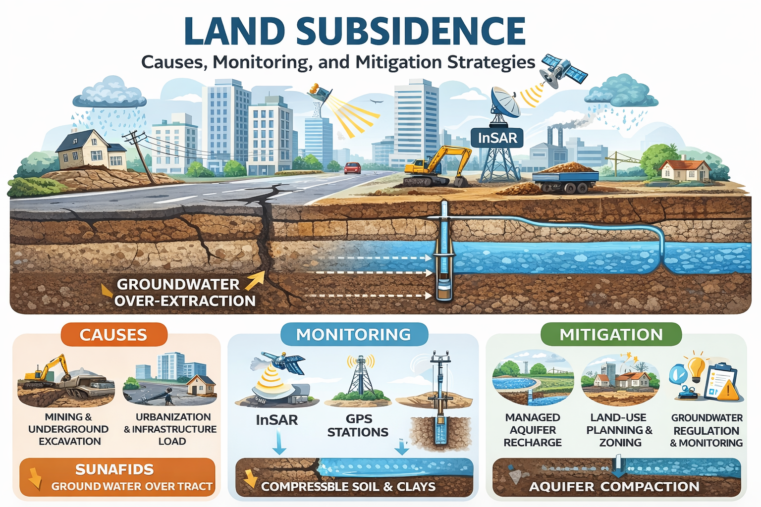
Major Causes of Land Subsidence
1. Groundwater Over-Extraction
The most common cause of land subsidence worldwide is excessive pumping of groundwater. When groundwater is withdrawn faster than natural recharge:
Pore water pressure decreases
Soil grains compact permanently
Aquifer systems lose storage capacity
Fine-grained sediments such as clays are particularly susceptible to irreversible compaction.
2. Mining and Underground Excavation
Mining operations and underground infrastructure projects create voids and stress redistribution, leading to:
Roof collapse and ground settlement
Progressive subsidence over mined areas
Surface cracking and slope instability
This is common in coal mining regions and underground tunneling zones.
3. Urbanization and Infrastructure Load
Rapid urban growth increases surface loading due to:
High-rise buildings
Roads and flyovers
Industrial installations
If the underlying soil and aquifer system is weak or compressible, surface loading accelerates settlement.
4. Natural Geological Processes
Natural consolidation of sediments, tectonic activity, dissolution of soluble rocks (karst terrain), and sediment compaction in deltaic regions can also contribute to land subsidence.
Impacts of Land Subsidence
Land subsidence has far-reaching environmental, economic, and social impacts:
Structural damage to buildings, roads, pipelines, and railways
Increased flood risk due to lowered ground elevations
Permanent loss of aquifer storage capacity
Disruption of drainage networks and natural water flow
Higher vulnerability to coastal flooding and sea water intrusion
Increased maintenance and rehabilitation costs
In subsiding regions, even moderate rainfall can trigger severe urban flooding.
Monitoring Techniques for Land Subsidence
Early detection and continuous monitoring are essential to manage subsidence risks effectively.
1. Ground-Based Monitoring
Precise leveling surveys
GNSS / GPS stations
Borehole extensometers
These methods provide high accuracy but limited spatial coverage.
2. Satellite-Based InSAR (Interferometric Synthetic Aperture Radar)
InSAR has become the most powerful tool for regional subsidence monitoring. It allows:
Detection of millimeter-scale ground movement
Large-area spatial coverage
Time-series analysis of subsidence trends
InSAR data is widely used to monitor urban subsidence, mining-induced settlement, and aquifer compaction.
3. Hydrogeological and Geotechnical Data Integration
Subsidence analysis must integrate:
Groundwater level trends
Aquifer lithology and compressibility
Pumping rates and abstraction history
This integrated approach helps identify cause-effect relationships rather than symptoms alone.
Link Between Groundwater Depletion and Land Subsidence
Groundwater depletion and land subsidence are directly interconnected. Once aquifer compaction occurs:
Storage capacity is permanently reduced
Recharge efficiency declines
Long-term water security is compromised
This makes subsidence not just a geotechnical issue, but a water sustainability crisis.
Mitigation and Management Strategies
1. Sustainable Groundwater Management
Regulating abstraction through permits and compliance frameworks
Promoting conjunctive use of surface water and groundwater
Implementing groundwater budgeting and demand management
2. Managed Aquifer Recharge (MAR)
Artificial recharge using rainwater, floodwater, or treated wastewater helps:
Restore groundwater levels
Maintain pore pressure
Reduce compaction stress
Recharge must be carefully designed based on aquifer characteristics.
3. Land-Use Planning and Zoning
Restricting heavy construction in subsidence-prone zones
Protecting recharge areas from surface sealing
Incorporating subsidence risk maps into urban planning
4. Monitoring-Based Adaptive Management
Continuous InSAR and groundwater monitoring
Early-warning systems for critical zones
Periodic review of abstraction and recharge measures
Case Insight: Urban Subsidence in Groundwater-Stressed Regions
Several Indian cities located on alluvial aquifers have recorded progressive land subsidence due to decades of groundwater over-extraction. Satellite data combined with groundwater monitoring reveals a strong correlation between falling water levels and surface settlement, underscoring the need for aquifer-based management and recharge planning.
Role of Hydrodynamic Modeling Consultancy Pvt. Ltd.
Hydrodynamic Modeling Consultancy Pvt. Ltd. provides integrated solutions for land subsidence assessment and mitigation, including:
Groundwater level and aquifer system analysis
Satellite InSAR-based subsidence assessment
Hydrogeological and geotechnical integration
Groundwater sustainability and recharge planning
Regulatory-ready technical reports and risk assessments
Our approach combines science, data, and policy alignment to manage subsidence risks effectively.
Conclusion
Land subsidence is a silent but severe geohazard driven largely by unsustainable groundwater use and subsurface disturbances. Without proactive monitoring and mitigation, its impacts on infrastructure, flood risk, and water security will intensify under climate change.
Addressing land subsidence requires integrated groundwater management, advanced monitoring technologies, and informed land-use planning. Sustainable solutions today are essential to prevent irreversible losses tomorrow.