
Aquifer Mapping, Protection & Remediation
Introduction
Aquifer mapping, protection, and remediation are the foundation of sustainable groundwater management in India and globally. Groundwater supplies nearly 60–70% of irrigation demand and over 85% of drinking water needs in India, making aquifer sustainability a critical national priority. Rapid urbanization, mining activities, industrial contamination, over-extraction, and climate variability have placed unprecedented stress on subsurface water systems.
Aquifer mapping services, combined with groundwater modelling and remediation planning, provide the scientific basis required for informed decision-making, regulatory compliance, and long-term water security.
At Hydrodynamic Modeling Consultancy Pvt. Ltd., we deliver aquifer mapping, protection, and remediation solutions using advanced hydrogeological investigations, GIS-based analysis, numerical groundwater models, and CGWA-compliant methodologies.
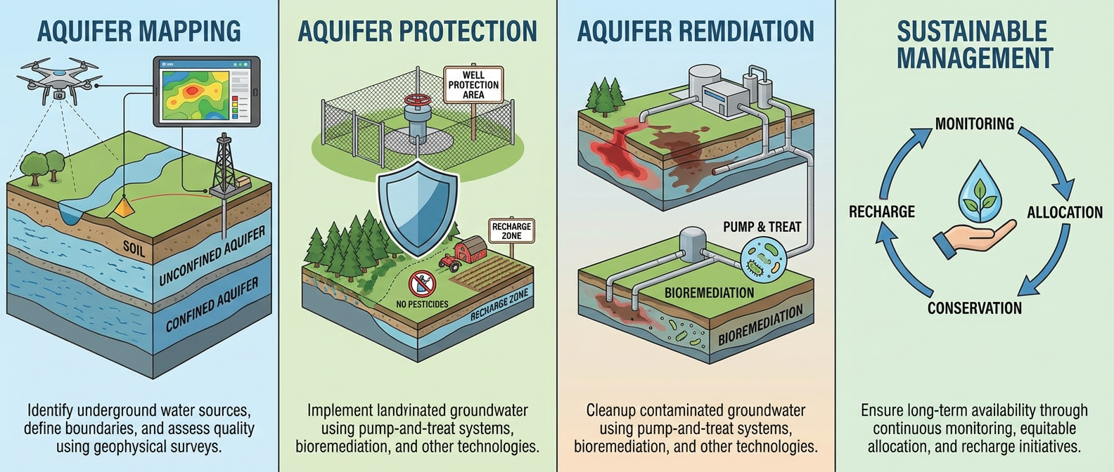
Aquifer Mapping Services for Sustainable Groundwater Management
Aquifer mapping is the systematic delineation and characterization of groundwater-bearing formations to understand how water is stored, transmitted, and replenished below the surface. It moves beyond basic well inventories and provides a three-dimensional understanding of aquifer systems.
Key Components of Aquifer Mapping
Aquifer extent, thickness, depth, and geometry
Lithology, stratigraphy, and structural controls
Hydraulic properties such as transmissivity and storativity
Recharge and discharge zones
Groundwater flow direction and hydraulic gradients
Aquifer vulnerability to contamination and over-exploitation
Tools and Techniques Used
Remote sensing and GIS-based geomorphology and lineament analysis
Borehole litholog interpretation and well inventory analysis
Geophysical surveys (VES, ERI, seismic where applicable)
Long-term groundwater level trend and fluctuation analysis
Pumping tests and aquifer parameter estimation
Numerical groundwater flow modelling using MODFLOW
Why Aquifer Protection Is Critical for Groundwater Sustainability
Aquifer degradation is often slow, invisible, and irreversible if not addressed in time. Once an aquifer is contaminated or severely depleted, recovery may take decades.
Major Threats to Aquifers
Unregulated groundwater abstraction beyond recharge capacity
Mining-induced dewatering and cone of depression effects
Industrial effluents, landfill leachate, and agricultural chemicals
Urban surface sealing reducing natural recharge
Seawater intrusion in coastal aquifers
Aquifer protection focuses on preventive and regulatory-aligned planning, including:
Identification and protection of natural recharge zones
Aquifer-based groundwater abstraction limits
Managed Aquifer Recharge (MAR) strategies
Vulnerability zoning and land-use controls
Long-term monitoring and sustainability indicators
Aquifer Remediation Solutions for Contaminated and Over-Exploited Aquifers
Aquifer remediation is required when groundwater quality or quantity has already been compromised. Effective remediation must be site-specific, model-driven, and scientifically validated.
Common Aquifer Remediation Approaches
Hydraulic containment and controlled pumping systems
In-situ treatment and reactive barriers
Dilution and flushing through managed recharge
Source control and plume migration management
Seawater intrusion barriers and freshwater injection systems
Numerical modelling plays a crucial role in predicting remediation outcomes and optimizing long-term performance.
Case Study: Aquifer Mapping and Remediation in a Mining-Affected Region (Central India)
Project Background
A large opencast coal mining project in Central India faced:
Declining groundwater levels in surrounding villages
Community concerns regarding drying wells and water scarcity
Regulatory scrutiny under CGWA and environmental clearance conditions
Key Challenges
Hard-rock aquifer with fracture-controlled groundwater flow
Seasonal rainfall variability masking long-term depletion trends
Mine dewatering altering regional groundwater gradients
Hydrodynamic Modeling Consultancy Pvt. Ltd. – Approach
1. Detailed Aquifer Mapping
Integrated geomorphology, drainage, and lineament mapping using GIS
Analysis of over 10 years of pre- and post-monsoon groundwater data
Delineation of weathered, fractured, and massive rock aquifer zones
Identification of mine-induced cones of depression
2. Groundwater Flow Modelling
Development and calibration of a MODFLOW-based groundwater model
Simulation of mine dewatering impacts over the life of the mine
Prediction of village-level groundwater level responses
3. Aquifer Protection and Mitigation Planning
Design of aquifer-specific recharge structures (check dams, recharge shafts, mine-void recharge)
Optimization of mine water reuse to reduce freshwater abstraction
Protection zoning of vulnerable recharge areas
Outcomes
Stabilization of groundwater levels in nearby habitations
Compliance with CGWA and environmental clearance conditions
Improved community confidence and long-term water security
How Hydrodynamic Modeling Consultancy Pvt. Ltd. Delivers Integrated Aquifer Solutions
As a specialized groundwater modelling consultancy, we provide end-to-end aquifer solutions for mining, industrial, urban, and infrastructure projects.
Our Core Aquifer Services
Regional and site-specific aquifer mapping in India
Groundwater flow and contaminant transport modelling (MODFLOW, SEAWAT)
Aquifer protection zoning and vulnerability assessment
Managed Aquifer Recharge (MAR) planning and design
Aquifer remediation solutions for mining and industrial impacts
CGWA-compliant groundwater impact assessments, CHR, IAR, and Water Audit reports
Our solutions are grounded in science, data, and regulatory alignment, ensuring technically sound and implementable outcomes.
Conclusion: Integrated Aquifer Mapping for Long-Term Water Security
Aquifer mapping, protection, and remediation are essential for achieving groundwater sustainability, regulatory compliance, and climate resilience. Without a scientific understanding of subsurface systems, groundwater management remains reactive and unsustainable.
Hydrodynamic Modeling Consultancy Pvt. Ltd. bridges the gap between hydrogeological science, numerical modelling, and policy frameworks, delivering reliable, future-ready groundwater solutions.
Groundwater may be invisible—but its management should never be uncertain.
FAQS
1) What is aquifer mapping?
Aquifer mapping is the scientific process of identifying and characterizing groundwater-bearing formations (aquifers) to understand their extent, thickness, depth, hydraulic properties, recharge zones, and groundwater flow behavior. It typically integrates hydrogeological field data, borehole logs, geophysics, GIS/remote sensing, and groundwater level trends.
2) Why is aquifer mapping important for groundwater sustainability?
Aquifer mapping helps define how much groundwater is available, how fast it can be replenished, and which zones are most vulnerable. This enables sustainable abstraction limits, recharge planning, protection zoning, and compliance-ready groundwater management decisions.
3) What is the difference between aquifer protection and aquifer remediation?
Aquifer protection is preventive—focused on avoiding depletion and contamination through zoning, recharge management, and abstraction control. Aquifer remediation is corrective—used when an aquifer is already contaminated or over-exploited and requires interventions such as hydraulic containment, in-situ treatment, or managed recharge.
4) Which methods are used for aquifer mapping in hard-rock areas?
Hard-rock aquifer mapping typically uses geomorphology and lineament mapping, well inventory and litholog analysis, geophysical surveys (VES/ERI), groundwater level monitoring, pumping tests, and groundwater flow modelling to understand fracture-controlled groundwater movement.
How does groundwater modelling (MODFLOW/SEAWAT) support aquifer management?
Groundwater models simulate aquifer behavior under different conditions—such as pumping, mine dewatering, climate variability, or recharge measures. MODFLOW supports flow simulation, while SEAWAT is used for density-driven flow and seawater intrusion studies, enabling predictive planning and optimized interventions.